An advice for BEIJING on LADAKH DISPUTE
This is an interesting conundrum to analyze and try to answer.
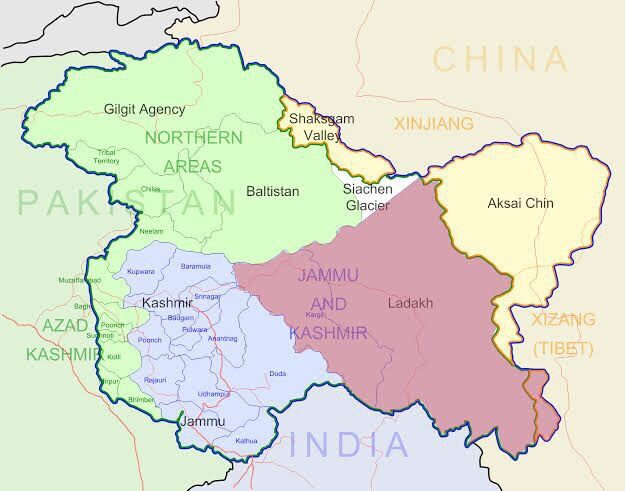
In my opinion, the whole saga emanates from declaring Akshai Chin as part of Ladakh Union Territory and make it to a law with Presidential decree, while Akshai Chin was under Chinese rule for decades.
Let’s go back in time to recall what India-China border tussle is. In 1865, British Surveyor Johnson draw a map and shown to Maharaja of Kashmir which includes Akshai Chin as part of Kashmir, whereas Kashmir doesn’t collect Taxes there. This is called Johnson’s line. In 1893, another British Surveyor Macartney created more detailed map with Karakoram mountains as border and submitted to London, which shows Akshai Chin as part of China. China went through several internal trifles and political instability prevailed, where no one came forward to oppose or accept the British proposal. British were unsure about the new map whether Chinese have accepted or not. Therefore within British regime, there were contradictory borders were prevailed – one created by Johnson in 1865 and another one created by Macartney on 1893. Simla accord was signed between Tibetan government (which was rebelling against Beijing) and British in 1914 to determine MacMohan line which draws the line in North Eastern Frontier Province (NEFP, which is called Arunachal Pradesh now). Beijing didn’t attend the Simla event and haven’t signed any accord. Simla accord states NEFP is part of India, and Tibet signed, but China was not party to that accord. But Tibet is still under China regime.
Therefore, in 1947 when British finally packed their bags to London, there were Akshai Chin and NEFP in dispute and unresolved with China. India carried forward that Sino-Indian Border uncertainty and confusion to its independence.
Indian Army was not patrolling Akshai Chin due to its cold terrain, despite claiming it as its border based on “Johnson’s Line”, whereas China believed that area was theirs as per “Macartney’s Line”. China built a 1200 Kms long road in the mountainous region in Akshai chin connecting Tibet and Xinjiang, which was unnoticed by India during the entire construction, since they didn’t patrol that area.
When they found there was road constructed through Chinese released maps 5 years later, Nehru proclaimed to retake Akshai chin (as per 1865 Johnson’s Line), and a war was broken between India and China in 1962. China has advanced and India retreated and a peace accord was reached which defined “Line of Actual Control (LAC)”, and both sides were agreed to patrol along LAC. LAC was almost a national border between India and China after 1962 war, but exact geo-codects were not defined. So, minor misunderstanding would erupt between two armies about where the LAC passes through. But the peace prevailed along LAC till 2019.
Hindu fundamentalist party BJP came to power in India, and they vowed to reclaim Jammu & Kashmir which is another border issue between India and Pakistan. With promulgated revocation of Article 370 in Indian Parliament, J&K was lost its special status hitherto was giving Kashmiris special privileges, pending UN-mandated referendum. J&K was divided into two union territories (which are directly governed by President with an appointed Governor). Ladakh UT was one of them. Ladakh UT map shows Akshai Chin as part of Ladakh Union Territory, based on 1865 Johonson’s line, without honoring 1962 post-war peace treaty signed between India and China and ignoring Line of Actual Control. This was made into a law with Presidential decree, who is the chief of all three armies of India. Eventually, India is declaring Akshai Chin as part of India, this is what China saw and perceived.
Following that Presidential decree, China had amassed their troops in the LAC to declare it’s their territory. As per 1962 post-war peace accord, both sides shall not use guns on each other. But Indian troops advanced beyond LAC in 2020 and attacked Chinese troops by hands without guns. After the chaos, 20 Indian soldiers were found to be dead, and most of them were dead because they were not given immediate medical attention due to bad weather and rough terrain. Chinese side casualties are still a “unknown number”. China is well equipped to station in sub-degree cold weather, but Indian troops are not. Knowing this well, China continued their peace-talks for several months to prolong, and in the end some “accord” has been reached. Troops in both sides are disengaging as of now. Full details are not visible to public eyes.
Similarly Line of Control (LoC) agreed between India and Pakistan after 1972 Indo-Pak war was also erased with article 370 revocation, which shows Pakistan-occupied-Kashmir (PoK) which was outlying LoC, shown as part of Jammu Union Territory.
China and India has another two issues: Arunachal Pradesh and Gilgit area.
Here’s the wiser counsel advice to China:
- With the advent of Beidou GPS, China should sit with India to define exact LAC between two nations, and both sides shall respect that. Call LAC as national border between India and China and end this border dispute once for ever.
- China shall re-negotiate NEFP as people are linguistically and culturally associated with India rather than China. Therefore, leave Arunachal Pradesh (or Tawang area) to India and sign an accord for that.
- Bring Gilgit area as key card in the negotiation of Arunachal Pradesh as the quid-pro-quo, so that India signs the accord for not claiming Gilgit area any longer, and consider it belongs to China. It was already under Pakistan Occupation and Pakistan had handed over that area to China, but India laid its claim based on “Johnson’s line” after revocation of Article 370.
India and China should join hands and work together to benefit each other, as India can complement China and vice versa. Industrial and Economical Co-operation between China and India will bring prosperity to both nations and its people. Enmity between them will bring more harm to India than to China, and Indian Politicians should think of the Non-Aligned Movement days and be firm to focus on their own best interests instead of becoming lackeys of some western nations.